Weakened Priscilla nears Mexico's Baja peninsula as Tropical Storm Jerry churns in the Atlantic
News > National News

Audio By Carbonatix
7:59 AM on Wednesday, October 8
The Associated Press
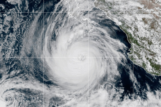
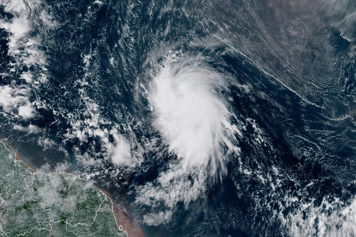
MIAMI (AP) — Priscilla lost its hurricane status Wednesday as it churned up Mexico's western Pacific coast while Tropical Storm Jerry strengthened in the Atlantic on its approach to the Leeward Islands, forecasters said.
Priscilla approached major hurricane status Tuesday before weakening to a tropical storm a day later with maximum sustained winds of about 60 mph (97 kph), the U.S. National Hurricane Center in Miami said.
The storm was bringing high surf and gusty winds to Baja California Sur, which was under a tropical storm watch from Cabo San Lucas to Cabo San Lazaro. Heavy rainfall and flash flooding were possible as the storm moves along Mexico’s Pacific coast and through the weekend in the Southwestern United States, forecasters said.
The storm was moving northwest at 9 mph (14 kph). It was centered about 235 miles (378 kilometers) west of the southern tip of Baja California, forecasters said. The hurricane center said the flood risk was increasing from all the rain Priscilla was dropping as it headed farther north.
In the Atlantic, Tropical Storm Jerry had top winds of 65 mph (105 kph). It was centered about 505 miles (813 kilometers) east-southeast of the northern Leeward Islands while moving west-northwest at 18 mph (29 kph).
Forecasters said Jerry was expected to strengthen gradually and could become a hurricane by the weekend. The core of the storm is expected to be nearing the northern Leeward Islands late Thursday.
On Thursday into early Friday, 2 to 4 inches (5 to 10 centimeters) of rain could fall across the Leeward Islands — bringing the risk of flash flooding. A tropical storm watch was in effect for Antigua, Barbuda and Anguilla; St. Kitts, Nevis and Montserrat; St. Barts and St. Martin; Saba and St. Eustatius; and Guadeloupe and the adjacent islands.
In the Pacific, meanwhile, Tropical Storm Octave was weakening about 515 miles (829 kilometers) south-southwest of the southern tip of Baja California. Its maximum sustained winds were 45 mph (72 kph) and it was moving east-northeast at 17 mph (27 kph). Octave, which wasn’t threatening land, was likely to dissipate Thursday, forecasters said.


